 Hidrográfico+
Type of resources
Available actions
Topics
INSPIRE themes
Keywords
Provided by
Years
Formats
Representation types
Update frequencies
Service types
Scale
Resolution
-
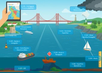
This geographic dataset (GDS) contains the coastal and local Navigational Warnings (ANAV) currently in force in S-124 format (https://registry.iho.int/productspec/list.do), in accordance with the S-100 specification (https://registry.iho.int/main.do) of the International Hydrographic Organization (https://iho.int/).. This dataset is part of the High-Value Datasets (HVD) identified in accordance with Commission Implementing Regulation (EU) 2023/138 under Directive (EU) 2019/1024 on open data and the re-use of public sector information. Citation: Instituto Hidrográfico (2026): S-124 – Navigational Warnings. https://doi.org/10.71683/a896657d-870a-4695-808f-2eec69be06d9
-
This Geographic Data Set contains the METAREAS, ie, weather warning areas.
-
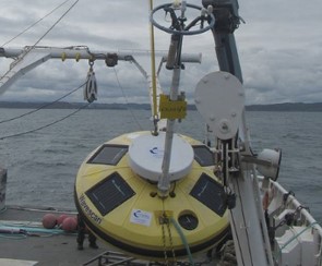
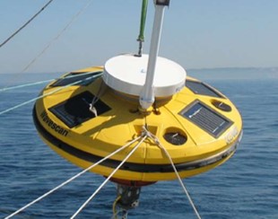
Este Conjunto de Dados Geográficos (CDG) contém a série temporal de observações da boia WaveScan Nazaré Costeira (CSA88/2), com início em 2009-03-22. São disponibilizadas as seguintes variáveis, com uma periodicidade de 60 minutos. Altura significativa (m) - https://vocab.nerc.ac.uk/collection/P09/current/VHM0/ Altura máxima (m) - https://vocab.nerc.ac.uk/collection/P09/current/VZMX/ Período médio (s) - https://vocab.nerc.ac.uk/collection/P09/current/VGTA/ Período de Pico (s) - http://vocab.nerc.ac.uk/collection/P09/current/VTPK/ Direcção Média no Período de Pico (º) - https://vocab.nerc.ac.uk/collection/P09/current/VPED/ Velocidade máxima (m/s) - https://vocab.nerc.ac.uk/collection/P09/current/GSPD/ Velocidade do vento (m/s) - https://vocab.nerc.ac.uk/collection/P09/current/WSPD/ Direção do vento (º) - https://vocab.nerc.ac.uk/collection/P09/current/WDIR/ Temperatura do ar (ºC) - https://vocab.nerc.ac.uk/collection/P09/current/ATMP/ Pressão atmosférica (hPa) - https://vocab.nerc.ac.uk/collection/P09/current/ATMS/ Humidade relativa (%) - https://vocab.nerc.ac.uk/collection/P09/current/RELH/ Temperatura da superfície do mar (ºC) - https://vocab.nerc.ac.uk/collection/P09/current/TEMP/ As observações em tempo-quase-real encontram-se disponíveis através dos serviços de dados indicados, limitados a um período temporal específico ( 4 dias). Para aceder à série completa de observações, ou a períodos passados específicos, deve ser endereçado um pedido para cedencia.dados@hidrografico.pt. Citação: Instituto Hidrográfico (2026): Boia Fugo Oceanor Wavescan Nazaré Costeira - Série Temporal de Observações. https://doi.org/10.71683/5bf408b0-9c6b-45a6-b5b3-d5d52317d541
-
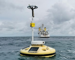
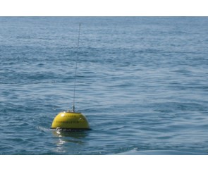
Este Conjunto de Dados Geográficos (CDG) contém a série temporal de observações da boia Fugro Oceanor WaveScan Nazaré oceânica (CSA88/1), com início em 2009-04-24. São disponibilizadas as seguintes variáveis, com uma periodicidade de 60 minutos. Altura significativa (m) - https://vocab.nerc.ac.uk/collection/P09/current/VHM0/ Altura máxima (m) - https://vocab.nerc.ac.uk/collection/P09/current/VZMX/ Período médio (s) - https://vocab.nerc.ac.uk/collection/P09/current/VGTA/ Período de Pico (s) - http://vocab.nerc.ac.uk/collection/P09/current/VTPK/ Direcção Média no Período de Pico (º) - https://vocab.nerc.ac.uk/collection/P09/current/VPED/ Velocidade máxima (m/s) - https://vocab.nerc.ac.uk/collection/P09/current/GSPD/ Velocidade do vento (m/s) - https://vocab.nerc.ac.uk/collection/P09/current/WSPD/ Direção do vento (º) - https://vocab.nerc.ac.uk/collection/P09/current/WDIR/ Temperatura do ar (ºC) - https://vocab.nerc.ac.uk/collection/P09/current/ATMP/ Pressão atmosférica (hPa) - https://vocab.nerc.ac.uk/collection/P09/current/ATMS/ Humidade relativa (%) - https://vocab.nerc.ac.uk/collection/P09/current/RELH/ Temperatura da superfície do mar (ºC) - https://vocab.nerc.ac.uk/collection/P09/current/TEMP/ As observações em tempo-quase-real encontram-se disponíveis através dos serviços de dados indicados, limitados a um período temporal específico (4 dias). Para aceder à série completa de observações, ou a períodos passados específicos, deve ser endereçado um pedido para cedencia.dados@hidrografico.pt. Citação: Instituto Hidrográfico (2026): Boia Fugo Oceanor Wavescan Nazaré Oceânica - Série Temporal de Observações. https://doi.org/10.71683/ddaa7491-5e09-41e4-9fa4-4f8298d32407
-
Este Conjunto de Dados Geográficos (CDG) contém a série temporal de observações da boia Fugro Oceanor WaveScan Leixões (CSA89/1), com início em 2010-05-23. São disponibilizadas as seguintes variáveis, com uma periodicidade de 60 minutos: Altura significativa (m) - https://vocab.nerc.ac.uk/collection/P09/current/VHM0/ Altura máxima (m) - https://vocab.nerc.ac.uk/collection/P09/current/VZMX/ Período médio (s) - https://vocab.nerc.ac.uk/collection/P09/current/VGTA/ Período de Pico (s) - http://vocab.nerc.ac.uk/collection/P09/current/VTPK/ Direcção Média no Período de Pico (º) - https://vocab.nerc.ac.uk/collection/P09/current/VPED/ Velocidade máxima (m/s) - https://vocab.nerc.ac.uk/collection/P09/current/GSPD/ Velocidade do vento (m/s) - https://vocab.nerc.ac.uk/collection/P09/current/WSPD/ Direção do vento (º) - https://vocab.nerc.ac.uk/collection/P09/current/WDIR/ Temperatura do ar (ºC) - https://vocab.nerc.ac.uk/collection/P09/current/ATMP/ Pressão atmosférica (hPa) - https://vocab.nerc.ac.uk/collection/P09/current/ATMS/ Humidade relativa (%) - https://vocab.nerc.ac.uk/collection/P09/current/RELH/ Temperatura da superfície do mar (ºC) - https://vocab.nerc.ac.uk/collection/P09/current/TEMP/ As observações em tempo-quase-real encontram-se disponíveis através dos serviços de dados indicados, limitados a um período temporal específico (4 dias). Para aceder à série completa de observações, ou a períodos passados específicos, deve ser endereçado um pedido para cedencia.dados@hidrografico.pt. Citação: Instituto Hidrográfico (2026): Boia Fugo Oceanor Wavescan Leixões - Série Temporal de Observações. https://doi.org/10.71683/1c90bff1-a5f3-4a73-b4e6-41d83c4c6dcd
-
Serviço de descarregamento (WFS) do CDG que contém a fronteira interna da zona marítima mais próxima da linha de costa, conforme definido no artigo 4.º, número 2., alínea b) da Diretiva (UE) 2017/2108 do Parlamento Europeu e do Conselho, de 15 de novembro de 2017, que altera a Diretiva 2009/45/CE relativa às regras e normas de segurança para os navios de passageiros (https://eur-lex.europa.eu/legal-content/PT/ALL/?uri=CELEX:32017L2108).
-
Serviço de visualização (WMS) que contém as posições geográficas das boias Datawell Waverider (https://datawell.nl/). Estas boias registam vários parâmetros oceanográficos, nomeadamente agitação marítima e temperatura da água do mar. Estas boias são geridas pelo Instituto Hidrográfico (https://www.hidrografico.pt/), Administração dos Portos da Região Autónoma da Madeira (https://apram.pt/) e Associação para o Estudo do Ambiente Insular (https://climaat.angra.uac.pt/boias/).
-
Serviço de descarregamento (WFS) do Conjunto de Dados Geográficos (CDG) que contém os limites da Zona Livre Tecnológica (ZLT) Viana do Castelo criada através da Portaria n.º 298/2023, de 4 de outubro (https://diariodarepublica.pt/dr/detalhe/portaria/298-2023-222421860). Esta ZLT tem como objetivo testar e desenvolver tecnologias de energia renovável oceânica, apoiando a inovação e a transição energética.
-
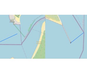
Serviço de visualização (WMS) do conjunto de dados geográficos (CDG) que contém as linhas de fecho das desembocaduras dos rios Minho e Guadiana, definidas na Resolução da Assembleia da República n.º 124/2018 (https://data.diariodarepublica.pt/dr/detalhe/resolucao-assembleia-republica/124-2018-115276178).
-
Serviço de visualização (WMS) do CDG que contém a fronteira interna da zona marítima mais próxima da linha de costa, conforme definido no artigo 4.º, número 2., alínea b) da Diretiva (UE) 2017/2108 do Parlamento Europeu e do Conselho, de 15 de novembro de 2017, que altera a Diretiva 2009/45/CE relativa às regras e normas de segurança para os navios de passageiros (https://eur-lex.europa.eu/legal-content/PT/ALL/?uri=CELEX:32017L2108).